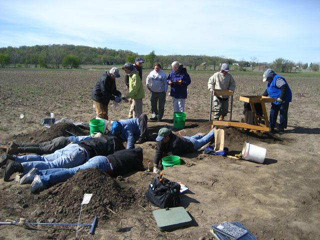
What do you call six or eight people lying flat on the ground with their heads in a small hole in a big farm field?

In this case, very dedicated volunteer archaeologists having a good time while also making a significant contribution to our understanding of Meskwaki life around 1840.
Sixty volunteers helped out with a 10-day dig this past March and April on the Amana Society farmland just outside of South Amana. They came from as far away as Minneapolis and St. Louis, but also from much closer to home, including a retiree from the Office of the State Archaeologist (OSA) at the University of Iowa, which coordinated the dig.
Julie Hoyer of North Liberty recently retired after many years as a librarian and archivist for the OSA. She was excited about the opportunity to get her hands in the dirt.

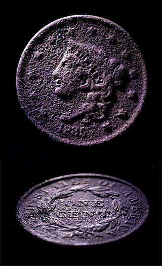
“In the screen I was working with, we found an 1835 coin,” she says. “I also found a nice, multi-colored cylindrical bead. I would do it again in a minute. It’s enjoyable!”
Jim Mallory, a retiree from Riverside, echoed that assessment. “I’ve always been interested in archaeology and geology,” he says. “It’s just avocational, but it’s fun.” Mallory found two-thirds of a pipe that may have originated in Ohio and a green, faceted bead.
Cindy Peterson, a research specialist with the OSA who coordinated the dig, was not surprised by the reaction of the volunteers. “You almost get a scream of delight when they find things,” she says with a smile.
The small finds that bring delight to volunteers contribute to the larger picture, Peterson quickly adds. “We’ve discovered that a good portion of what was known as the Patterson Trading Post is intact even though this field has been plowed since the 1850s,” she notes.
“By studying the trading post, we were also able to identify the adjacent Meskwaki village, thanks to an 1850s story handed down in the family of Amana Colonist Ewald Leichsenring,” Peterson adds. One of his great-granddaughters, Ramona Gerard of Amana, told how Ewald stood on a prominent hill and could see the Meskwaki village in the distance to the north. Peterson and her volunteers went to that spot and found archaeological traces of the village.
This is OSA’s second venture into Iowa byways. The first identified cultural and historical resources and a management plan for the Loess Hills Scenic Byway along Iowa’s western border.
How did they find the trading post in a field of hundreds of acres?
First, they went to the approximate area of a “Trading House” cabin drawn on an 1843 map. There, the workers divided a section of the field into 55 grids each 10 meters square. Next, they collected surface artifacts and counted which grids had the most. The high-count grids were revisited with metal detectors. One of those grids had more than 190 hits, and that’s where the group drilled their first auger holes.
The process worked beautifully. Not only did the diggers find dozens of small items, they also located the trading post’s ash pit, another 3-foot deep pit, and a root cellar.
The Patterson Trading Post site is only the third such trading post discovered in Iowa, Peterson adds. The discoveries on this particular site provide new information about what the Meskwaki and the traders were exchanging.
That information is treasured not only by the OSA professionals, their volunteers, and the archaeological community—it’s also of great moment to Peter Hoehnle, coordinator of the Iowa Valley Scenic Byway and the executive director of the Iowa Valley Resource Conservation and Development Council, based in Amana.
His organization and the OSA have worked together to create a new management plan for the byway, which follows the Iowa River and stretches from Montour on the west to the Amana Colonies on the east. That plan will guide the marketing of the area as a tourist destination, but it also addresses issues of conservation of resources. And it has done so with many a community meeting to ensure that the people who live in the byway have been consulted about what is important to them, both historically and culturally.
“This site tells an important story that we’ve been highlighting in our management plan,” Hoehnle explains. “It’s about the unique interaction between the Meskwaki, the Amana area, and, later, the Amana people. Those interactions continued for some 70 years. It’s an unusual American story and it’s one that we hope to hang our hat on.”